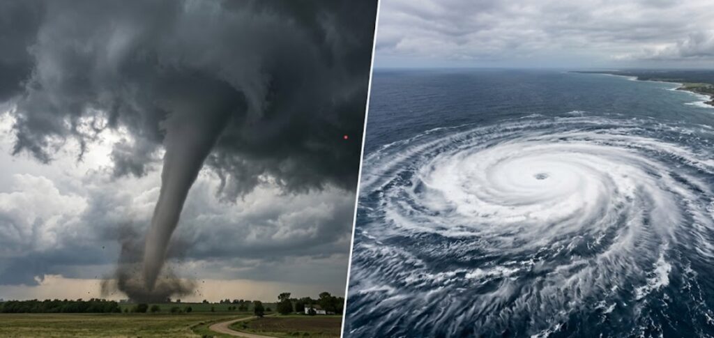
They both spin. They both destroy. They both make the evening news with footage of flattened houses and stunned survivors. And because of that, tornadoes and hurricanes get lumped together in the public imagination as basically the same thing at different sizes. A hurricane is just a big tornado, right? A tornado is just a small, angry hurricane?
Not even close. These are fundamentally different phenomena, born from different conditions, operating on different scales, and dangerous for different reasons. Confusing them isn’t just a meteorological error. It’s a practical one. The way you prepare for a hurricane is completely different from the way you respond to a tornado warning. If you treat one like the other, you’re making yourself more vulnerable, not less.
Let’s break down what actually distinguishes these two spinning monsters of the atmosphere.
The Scale: Continent vs. Neighborhood
The most obvious difference is size, but the numbers are more extreme than most people realize.
A large hurricane can span six hundred miles across, with tropical storm force winds extending hundreds of miles from the center. Hurricane Sandy in 2012 had a wind field over a thousand miles wide. The entire system is visible from space as a massive, structured spiral, with spiral arms, a defined eye, and a symmetry that’s almost beautiful if you don’t know what it’s doing to the surface below.
A tornado, even a large one, is rarely more than a mile or two wide. Most are much smaller, measured in hundreds of yards. The largest tornado ever recorded, the 2013 El Reno tornado in Oklahoma, was 2.6 miles wide, an absolute monster, and it was still dwarfed by even a modest hurricane. A tornado can fit entirely inside the eye of a hurricane with room to spare.
This scale difference shapes everything about how we experience these storms. A hurricane is a regional event. It affects entire coastlines, multiple states, sometimes multiple countries. It sits over an area for hours or days. A tornado is a local event. It carves a narrow path of destruction that can be measured in yards wide and miles long, and it’s gone in minutes.
The Birthplace: Ocean vs. Land
Hurricanes are ocean creatures. They are born over warm tropical waters, typically when sea surface temperatures exceed about twenty-six degrees Celsius or seventy-nine degrees Fahrenheit. The warm water evaporates, the moisture rises, and if the atmospheric conditions are right, the thunderstorms organize around a center of low pressure. A tropical depression becomes a tropical storm becomes a hurricane, all powered by the heat energy stored in the ocean.
This is why hurricanes weaken rapidly once they move over land. They’re cut off from their energy source. The ocean is their fuel, and without it, they spin down. They can still cause catastrophic inland flooding, as Hurricane Helene recently demonstrated, but their wind intensity drops. A hurricane that’s been over land for a day is a shadow of the storm that made landfall.
Tornadoes are land creatures, born from severe thunderstorms. The classic setup involves a supercell thunderstorm, a rotating storm with a mesocyclone, a persistent, rotating updraft. The ingredients are warm, moist air near the surface, cold, dry air aloft, and something called wind shear: winds changing speed and direction with height. Wind shear creates horizontal rotation in the atmosphere. A thunderstorm’s updraft tilts that rotation vertical. The rotating updraft tightens and intensifies, and if conditions are right, a funnel cloud descends to the ground.
Tornadoes don’t need an ocean. They can form over land, over lakes, even over cities. The conditions that produce them, warm moist air from the Gulf of Mexico colliding with cool dry air from the Rockies, are why Tornado Alley in the central United States is the tornado capital of the world. The geography is unique, and so is the frequency of tornadoes it produces.
The Lifespan: Days vs. Minutes
A hurricane can last for weeks. Hurricane John in 1994 lasted thirty-one days, tracking across the entire Pacific basin. Even a typical hurricane has a lifespan of a week to ten days from formation to dissipation. This gives forecasters time. Hurricanes are tracked from the moment they’re a disturbance off the coast of Africa or a swirl in the Caribbean. Warnings go out days in advance. Evacuations can be ordered. The track and intensity forecasts have improved dramatically over the decades.
A tornado lasts minutes. The average tornado is on the ground for about five minutes, though some persist for half an hour or more. The longest-lived tornado on record, the 1925 Tri-State Tornado, was on the ground for three and a half hours, but that’s a historic outlier. The typical tornado gives almost no lead time. Tornado warnings are issued when a tornado is indicated by radar or spotted on the ground. The average warning lead time is around ten to fifteen minutes. That’s enough time to get to a shelter if you’re paying attention. It’s not enough time to evacuate or make complex preparations.
This difference in timescale creates fundamentally different risk profiles. Hurricane preparedness is about planning days ahead. Tornado preparedness is about having a plan and executing it in moments when the warning comes.
The Wind: Sustained vs. Instantaneous
Both storms produce destructive winds, but the character of those winds is different in ways that matter for engineering and survival.
Hurricane winds are sustained. They blow consistently in one direction for hours, shifting as the storm passes. A hurricane wind rating, the Saffir-Simpson scale from Category 1 to Category 5, is based on sustained wind speed averaged over one minute. A Category 5 hurricane has sustained winds over 157 miles per hour. These winds push against structures relentlessly. They uproot trees. They peel roofs. They drive storm surge inland, which is often the deadliest element of a hurricane.
Tornado winds are instantaneous and rotational. The Enhanced Fujita Scale, from EF0 to EF5, is based on damage surveys after the fact. It’s extremely difficult to measure tornado wind speeds directly because tornadoes destroy weather instruments. The estimates are derived from the damage they leave behind. An EF5 tornado, with estimated winds over 200 miles per hour, doesn’t just damage buildings. It scours the ground, removes pavement, and throws vehicles like toys. The winds in a tornado are also rotating rapidly around a tight center, creating extreme horizontal shear. One side of a house experiences winds in one direction, the other side experiences winds in the opposite direction. Structures are twisted apart rather than just pushed over.
A hurricane can spawn tornadoes, and when it does, it combines the worst of both worlds. The embedded tornadoes within a hurricane’s rain bands are often fast-moving and short-lived, but they add a layer of localized, extreme damage on top of the broader destruction of the hurricane’s winds and flooding.
The Water: Surge vs. Rain
Both storms bring water, but in very different forms that require different responses.
Hurricanes bring storm surge, the abnormal rise of seawater driven inland by the storm’s winds. Storm surge is the deadliest element of a hurricane. It’s a wall of water that pushes ashore, flooding coastal communities in minutes. The surge is highest near the eye, particularly in the right-front quadrant of the storm relative to its direction of movement. Inland flooding from torrential rain also occurs, but the surge is unique to coastal storms, and it’s the reason coastal evacuations are ordered.
Tornadoes bring no surge. They’re inland phenomena. The flooding associated with tornadoes comes from the same thunderstorm that produced the tornado, which may bring heavy rain and hail. But flooding is not the primary danger of a tornado. The wind is.
The distinction matters for response. In a hurricane, moving away from the coast is often the critical action. In a tornado, getting low, getting underground if possible, and putting walls between you and the outside is what saves lives. Different threats, different actions.
The Predictability: The Forecasting Gap
Hurricane forecasting has improved steadily for decades. Track forecasts are now accurate enough that five-day forecasts are as good as three-day forecasts were twenty years ago. Intensity forecasting is harder. Storms can rapidly intensify overnight, catching forecasters and communities off guard. But the track, at least, gives ample warning of where the storm is heading.
Tornado forecasting is probabilistic, not deterministic. Meteorologists can identify the conditions favorable for tornadoes hours or even days in advance. A Tornado Watch means conditions are right. It covers a broad area and a period of several hours. But they cannot predict where a specific tornado will touch down. A Tornado Warning means a tornado has been detected by radar or spotted by a trained observer. It covers a small area for a short time. It’s immediate. It’s specific. It’s the signal to act.
This gap is not a failure of forecasting. It’s a reflection of the physics. Hurricanes are large, stable systems governed by large-scale atmospheric patterns. Tornadoes are small, chaotic, and exquisitely sensitive to local conditions that can’t be measured with enough density to predict their formation precisely. The science is advancing, but the gap between hurricane and tornado predictability is unlikely to ever fully close.
The Experience: What It Feels Like
A hurricane is a slow-motion disaster. The sky darkens. The wind picks up. The rain begins, hours before the worst arrives. The storm builds, peaks, and then there’s the eerie calm of the eye, a strange, still interlude before the backside of the storm arrives. The whole experience lasts a day or more. The aftermath is a landscape of widespread, general destruction, trees down everywhere, power out for miles, flooding that stretches to the horizon.
A tornado is a sudden, violent, and intensely local catastrophe. The sky turns a strange color, greenish or bruised purple. There’s a roar that survivors describe as a freight train or a jet engine. Then it’s on you. The pressure drops so fast your ears pop. The world becomes a blur of debris. And then, minutes later, it’s over. The sun comes out. The birds start singing. And one path through the neighborhood, often just a few hundred yards wide, is completely destroyed, while houses a block away are untouched.
Both experiences are terrifying, but the terror has a different texture and a different duration.
The Bottom Line
Tornadoes and hurricanes are not the same thing at different sizes. They are different species of storm, born in different environments, operating on different scales of space and time, and presenting different threats that require different responses.
A hurricane gives you time to prepare, to evacuate if you’re in a storm surge zone, to board windows, to gather supplies. It’s a marathon threat. A tornado gives you minutes to act, to get to your shelter, to protect your head, to wait out the few minutes of violence. It’s a sprint threat.
Confuse the two, and you’ll make the wrong decision when minutes or miles matter. Respect them as the distinct phenomena they are, and you’ll know when to run from the water and when to hide from the wind. In both cases, the storms demand humility. They are reminders, spinning and roaring, that the atmosphere is larger than us and indifferent to our plans. All we can do is understand them clearly, prepare accordingly, and get out of the way.